ARTICLE
3D Scan to BIM for Structural Engineers: Turning Point Clouds into Accurate As-Built Models
Reality capture turns an existing structure into a model you can actually trust, but only if the scan, the registration and the level of detail are matched to the decision the model has to support.

What scan-to-BIM actually is
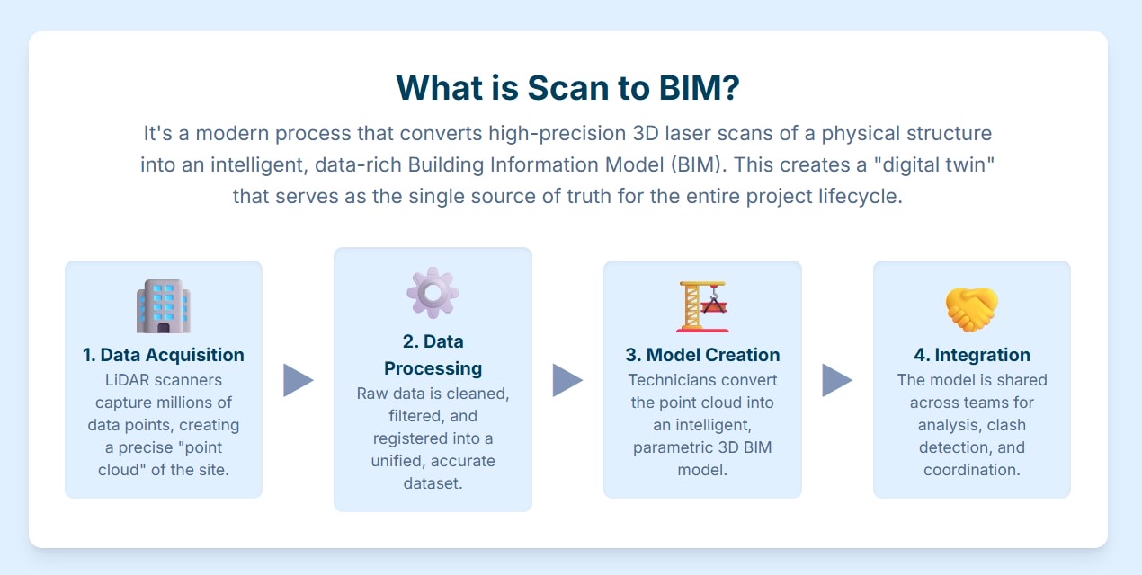
Scan-to-BIM turns an existing structure into an accurate digital model by measuring it directly, rather than reconstructing it from drawings that may no longer match what was actually built. The workflow runs in four stages, and the accuracy of the finished model depends on all four being done properly, not just the last one.
A terrestrial laser scanner captures the structure as a point cloud — millions of measured points, gathered scan station by scan station until coverage is complete. The individual scans are then registered into one coordinate system, tied to survey control where the project needs it, and cleaned of noise so the dataset reads as one coherent structure rather than a set of overlapping snapshots. From there, the point cloud is traced into BIM elements at the level of detail the project actually requires, and the resulting as-built model is issued into the project's common data environment, where other disciplines coordinate design and renovation work against it.
Scoping a scan-to-BIM package
A scan-to-BIM package succeeds or fails on decisions made before the scanner is ever switched on. The scope has to answer the following questions explicitly, not by default.
- The target level of detail, element by element. Structural framing modeled for design use is a different job, and a different price, than a coordination-grade model intended only for visual reference.
- The coordinate system and control the scan has to tie into, especially where the model needs to align with an existing survey, a site grid, or a previous phase of work.
- The deliverable format — native Revit, IFC, or both — and which discipline's modeling conventions the elements follow.
- The accuracy tolerance the model has to hold, stated as a number and matched to what the design decision actually requires, not left as an unstated assumption.
- What gets modeled as a true element versus left as reference geometry, since not every captured surface needs to become a parametric object, and deciding that in advance keeps the programme realistic.
A scope this specific takes longer to write than an instruction to scan and model the building. It is also what keeps the delivered model matched to what the design actually needs, instead of more detail than anyone will use or less than the engineer relying on it assumed they were getting.
What actually drives model accuracy
Millimeter accuracy describes the scanner, not the finished model, and the two get treated as interchangeable more often than they should be. A scanner's stated precision sets a ceiling; what the delivered model actually achieves depends on what happens after the scan, not the specification sheet of the instrument that captured it.
Point density and coverage have to be sufficient that every surface the model needs is captured without gaps, because a scan position plan that is too sparse leaves the modeler estimating in exactly the areas that matter most. Registration has to be tied to a proper control network on anything larger than a single room, since cloud-to-cloud registration without control can drift across a large structure in ways that stay invisible unless someone checks for them. And the only reliable way to confirm a model matches the scan it came from is to verify it against the point cloud directly, element by element, before it is issued.
Where scan-to-BIM goes wrong
The same handful of failures shows up across enough projects that they are worth naming directly.
- The level of detail was never agreed. The design team assumes a model built for structural use; the scan was only ever intended to support visual coordination, and the mismatch surfaces mid-project.
- There is no control network. Individual scans are registered to each other but not to a fixed reference, so accuracy that looks fine locally drifts across a large or multi-building site.
- Obstructed areas get modeled from assumption. Stored material, fit-out, and inaccessible risers leave gaps in the point cloud, and those gaps get filled by guesswork instead of being flagged as unverified.
- The model is never checked against the cloud. Geometry gets modeled once and issued, with nobody confirming afterward that it actually traces the scan it was built from.
- The point cloud is treated as disposable. Once the model is delivered, the source data is discarded, and with it the only independent way to verify the model or re-check it later.
Every one of these is avoidable with a scope that states the requirement up front and a delivery that includes evidence, not only the finished model.
Matching accuracy to the decision, not the project
Not every element on a structure needs the same accuracy, and treating the whole scan as one uniform standard wastes budget in some areas and under-serves it in others. A connection that a reinforcement design has to tie into within a few millimeters needs that precision measured and modeled explicitly. A perimeter wall being captured only for space planning does not.
The efficient approach states accuracy requirements by element or by zone, not as a single figure for the whole building: tight tolerance where a new structural element has to fit against an existing one, looser tolerance where the model serves as context rather than a design constraint. That distinction, made at the scoping stage, is what keeps a scan-to-BIM package from being priced and programmed as though every part of the structure mattered equally to the decision it exists to support.
Choosing how the work gets delivered
The commercial structure should follow the scope, the same way it would for any other detailing or modeling package. A well-defined target — stated level of detail, stated tolerance, stated deliverable format — suits a fixed-price arrangement, because both sides can measure the finished model against a specification agreed before the scanner was mobilized. A survey where the extent of the structure or the condition of the existing records is still uncertain suits a time-and-materials arrangement with a checkpoint once the point cloud is in hand.
Beyond price, the questions worth resolving before work starts are about what gets handed over at the end: the registered point cloud alongside the model, not the model alone; a stated accuracy tolerance the deliverable was checked against; and a named engineer accountable for the modeling, rather than an anonymous team. A scan-to-BIM package that includes all three behaves like a foundation the rest of the project can build on. One that includes only the model is a drawing with better production values, carrying the same risk as any other unverified as-built.